LocalFocus toegankelijk voor iedereen

  • ♿ Met de nieuwe toegankelijkheidsmodus is de data achter jouw kaart nu ook beschikbaar voor blinden en slechtzienden via een screenreader.
  • ⌨️ De widgets gemaakt met onze kaartmodule zijn nu ook volledig zonder muis te gebruiken, gewoon met je toetsenbord.

Toegankelijkheidsmodus

Omdat wij het belangrijk vinden dat onze widgets voor iedereen bruikbaar zijn, hebben we een toegankelijkheidsmodus ontwikkeld. Met deze nieuwe feature krijgen gebruikers de mogelijkheid om de data achter een widget in een overzichtelijke tabel te bekijken.

Deze nieuwe weergave is geoptimaliseerd voor screenreaders, zodat je jouw verhaal ook aan blinden en slechtzienden kunt overbrengen.

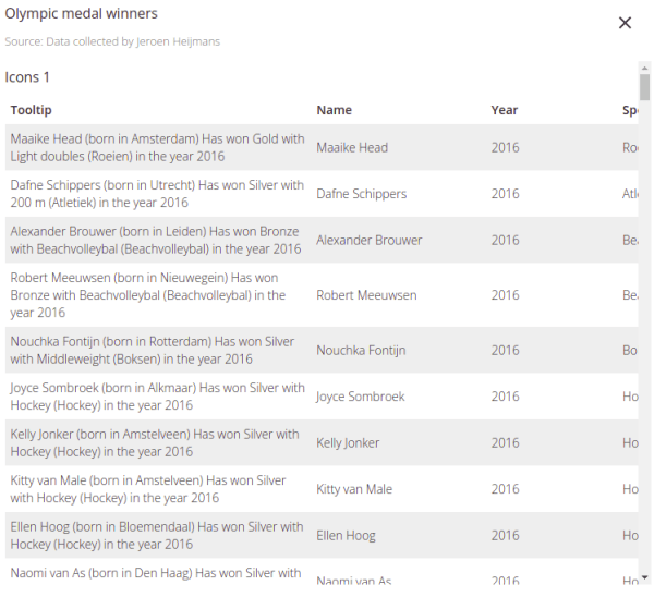
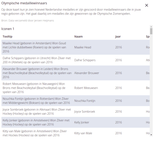
Neem bijvoorbeeld deze kaart, met Olympische medaillewinnaars per regio.

Kaart met Olympische medailles behaald door Nederlanders

Met de nieuwe toegankelijkheidsmodusbutton rechtsonder in de widget open je de tabelweergave.

Geen mogelijkheid om een muis te gebruiken, maar toch interacteren met een LocalFocus kaart? Geen probleem! Je kunt nu gemakkelijk door alle interactieve elementen heen ’tabben’ en navigeren door de kaart met de pijltoetsen van je toetsenbord.

In onze handleiding lees je alles over de nieuwe toegankelijkheidsmodus.

Visualisatie- en tabelmodule

Vanaf nu is de modus beschikbaar in onze kaartmodule. We blijven niet stilzitten, en zullen deze updates in de nabije toekomst ook doorvoeren voor de visualisatie- & tabelwidgets.

LocalFocus accessible for everyone

  • ♿ With our new accessibility mode the data behind your map is now available for blind and visually impaired users via a screen reader.
  • ⌨️ The widgets made with our map module are now fully usable without a mouse, using your keyboard.

Accessibility mode

Because we think it’s important that anyone can use our widgets, we’ve developed an accessibility mode. With this new feature, users get the possibility to view the data behind a widget in a table layout.

This new view is optimized for screen readers, so that your story can be told to blind and visually impaired users as well.

Take this map for example, one with Olymic medal winners per region.

How to open accessibility mode

With the new accessibility mode button in the bottom right corner of the map, you can open the table layout view.

Accessibility mode example

Not able to use a mouse but you still want to interact with a LocalFocus map? No problem! You can now easily ’tab’ and navigate through the map using the arrow keys of your keyboard.

In our tutorial you will read everything you need to know about the new accessibility mode.

Visualisation- and table module

The new modus is now available in our map module. We’ll add the new accessibility updates to the visualisation- and table module in the near future.

New: Aerial photos and drag & drop map layers

The map module has two new functionalities!

  • 🛰️ It is now possible to use aerial photos of The Netherlands as a map background.
  • 🖱️Map layers, such as icons, that you added manually can now be easily repositioned by dragging them.

Aerial photos of The Netherlands

PDOK has made a beautiful set of aerial photos of The Netherlands from 2020 publicly available! You can now use these photos as a background in our map module.

Use them to create an interactive map or to download as an image. For example, put the hotspots for airplane spotters on the map! Do you see which airport this is?

To do this, go to the map options tab in the editor. Then click on map options in the options that appear. Then click Aerial images (The Netherlands only) to activate the basemap.

Drag & drop map layers

Have you drawn map elements by hand, but is it in the wrong place? You can now easily drag it with your mouse to the correct location!


Help, something is not working for me

Contact us and we will try to fix it.

Nieuw: Luchtfoto’s en verplaatsen van kaartlagen

De kaartmodule heeft er twee nieuwe functionaliteiten bij!

  • 🛰️ Het is nu mogelijk om luchtfoto’s als kaartondergrond te gebruiken voor heel Nederland.
  • 🖱️Kaartlagen, zoals iconen, die je handmatig hebt toegevoegd kunnen nu gemakkelijk worden verplaatst door ze te verslepen met je muis.

Luchtfoto’s van Nederland

PDOK heeft sinds februari 2021 een mooie set luchtfoto’s  van Nederland uit 2020 publiekelijk beschikbaar gesteld, en wij zijn daarmee aan de slag gegaan! Jij kan vanaf nu deze foto’s gebruiken als ondergrond in onze kaartmodule.

Gebruik ze voor het maken van een interactieve kaart of om te downloaden als afbeelding. Zet bijvoorbeeld de hotspots voor vliegtuigspotters op de kaart! Zie jij welk vliegveld dit is?

Om dit te doen ga je in de editor naar de tab kaartopties. Klik vervolgens op kaartopties in de lijst die verschijnt. Vink vervolgens Luchtfoto’s Nederland aan om de ondergrond te activeren.


Kaartlagen verplaatsen

Heb je een van de losse elementen op de kaart getekend, maar staat deze op de verkeerde plek? Je kunt hem nu gemakkelijk verslepen naar de juiste locatie!

Help, er werkt iets niet voor mij

Dat is vervelend. Neem contact met ons op, dan gaan we kijken of we het kunnen fixen.